Skip to content
Knightshoots Landscape Photography
  • Home
  • Biography
  • Galleries
    • Landscapes
    • Animals and Birds
    • Still Life
    • Portraits & Headshots
  • Blog
  • Headshots
  • Contact
  • Shop
My Adventures

Wick Lighthouse, Lifeboat House and Old Castle, and Whaligoe…


Scotlands Highlands 2020: Part Four

25 July 2020

What happens when you don’t listen to your exhausted body?… Today I was going to find out.

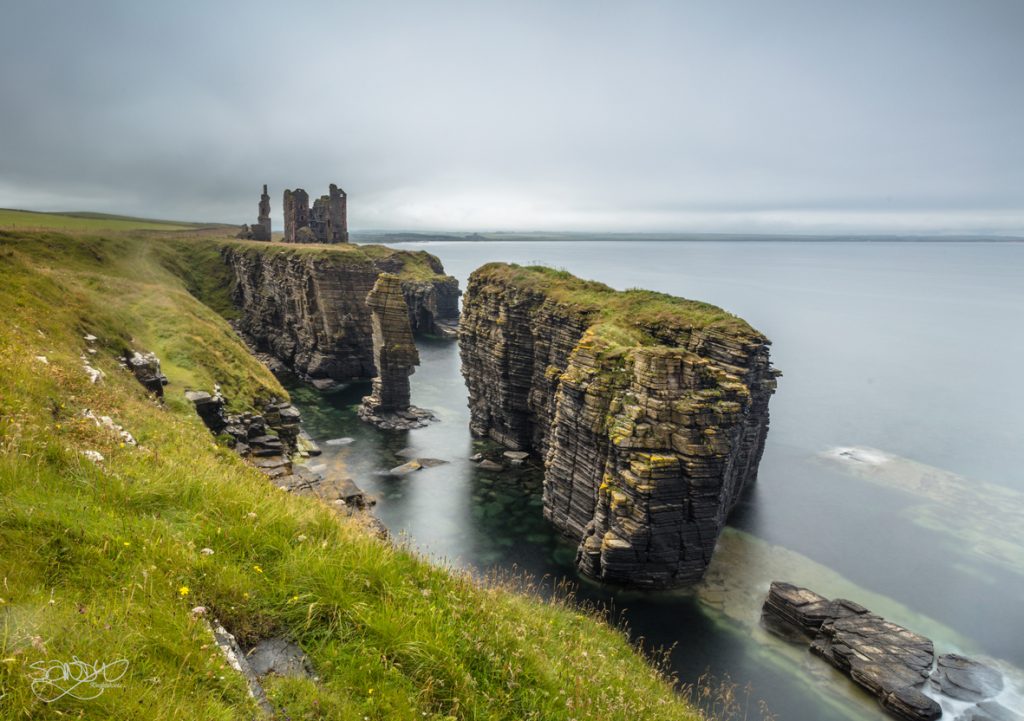
Having stayed right by the harbour overnight, I was in a really nice place to explore Wick South Pier Lighthouse (a cute diddy one!) and the lifeboat house. Turns out I was the wrong side of the bay, and on top of this, I totally missed a second viewpoint I had hoped to use, that WAS on the side I was on. (ugh! Great start!) As the light wasn’t exactly exciting, I guess it wasn’t a real issue in the big scheme, since I could always try again on another trip. I drove the short distance to a road nearer the lifeboat house, and took the short walk down the hill to explore it. The tide was out as I explored, and it quickly became obvious that it needed to be in to make any nice shot work. I looked around anyway to find a nice viewpoint, and took pictures on the phone as a memory aid. The weather was very still, but a flat grey, so I decided to try again a bit later in the hope that I might have better luck. For now, I drove to Wick Old Castle instead, to while away the time. I was so glad I did, because I found the boards giving its history to be quite fascinating!

The castle is on a bit of land that juts out into the ocean, pretty much the same as Castle Sinclair Girnigoe, (and, as it turned out, several others) Much of it has fallen and disappeared, leaving just a square tower, but there are areas that are unexcavated, so there may be more footings under the ground. Its history is pretty obscure, but the bit that caught my attention was that its likely builder, way back in the 1100’s was half Norse. Apparently during this time, Caithness, Sutherland and all of the western Isles islands were actually under control of the Norwegians (or more accurately the Norse, whose land back then included areas we now know as Norway, Denmark and Sweden) Their ownership of this part of Scotland followed a treaty that had been passed shortly after Edgar became King in 1097. It wasn’t a hard fisted control, with the local land owners being pretty much left to their own devices, but I found it fascinating to consider that the far north east of Scotland may have been ‘Norwegian’ at one point nonetheless. Harald Maddadsson, the likely builder, was Earl of Orkney and Caithness, and this castle may have been built to mark his territorial rights on the mainland. As I hiked over the peninsular, I took a photo of the remnants of the castle looking back along the path I had just walked, but I was really nervous of River on this peninsular as she seemed intent on exploring the edges. Eventually I moved back to the mainland bit, and walked along to an end viewpoint instead.

Wick Castle

I loved the view from here and took several photos, waiting in between each for the few tourists to clear the scene. It was quite relaxing, and by the time I had taken a few, I happily went back to the camper for a nice cuppa. There were still a couple of hours until high tide by this point, so I chilled even more by having a nap! Totally unheard of for me, but well needed obviously, as it was no effort to fall asleep.

When I awoke, the sky was even more grim looking but I made my way back to the Lifeboat house determined to try a shot there. The grey meant that no sunset would be likely, so I didn’t think it would be worth waiting for that, and I was just going to have to try and work with the flat grey look and the high tide. I could see the weather working for the shot I hoped for however, so wasn’t deterred. As soon as I was in position though, it seemed everything started to work against me. The best position to photograph the lifeboat house was right by a tall wall with a ledge that was just the right height to see over, but that was as far as my luck went. I couldn’t work out which lens was best, as none seemed to do what I wanted – turns out I needed a lens in between the ones I owned (something that covers a 70mm-100mm focal range!) The wall itself proved to be a really complicated issue, with it being too high for the tripod, (even at its lowest position) and too low to work without one. It didn’t help by forcing me to balance on a slim ledge while I worked either. I tried putting the camera directly on the wall, nope, it tipped downwards to the sea only. I tried propping the lens a little with all my drying cloths to get the house in position, then I couldn’t see clearly enough to focus properly, because I was too high to view it without crouching (on a thin ledge remember). I tried handheld. That was a disaster, as I really struggle with that even in the best conditions. I tried all sorts, but simply couldn’t get my head around it! I just got myself riled up and angry instead!

Then River began playing up. She ran off into the road eventually, resulting in me having to climb back down, tie her to a lamp-post and feeling really guilty for doing that. It started drizzling, so I then had to try and keep the lens dry (with the very cloths I was using to prop the lens up on) – off came my jacket (to use as a prop up tool instead) as I continued to fight with myself for this shot. Eventually it just out and out rained. I could feel a fierce temper rising inside, borne out of the feelings of complete frustration and inadequacy, and then I finally realised that today, this wasn’t going to happen if I continued. Irritated with myself and River, and now completely angry and fed up, I packed everything away and stomped back to the camper in the foulest of moods. What I really needed to do was to just jump over the wall, and take the shot. But the rain, River, and a high tide all prevented me from doing that, so I left it before I ended up throwing stuff around!! On looking at the photos after the event, none of them are even in focus. I have absolutely NO idea why even THAT failed, as I was sure I had it pin sharp in the viewfinder. (probably where I couldn’t see the screen properly now I think of it)

poor focus, too low, too high, and finally, rain… just a handful of the frustrations!

The South Pier lighthouse was equally uninspiring now the rain was here, so I decided to abandon the shoot altogether, leaving Wick completely. My mood was that low.

Once away from the area I paused to look at my map and have a sensible think about where I wanted to go from here. I thought I might try Whaligoe steps as my next destination, as I knew it wasn’t too far, and that there were some lovely shots taken here by other photographers. If I was lucky, there may be parking there for the night so I could simply chill out and explore in the morning.

When I arrived I realised that parking was very limited… maybe 6-8 vehicles, less if big ones pulled in. As I had arrived later in the day, most tourists were already gone, so parking wasn’t an issue for me thankfully. In the car park I was met by local resident Davy (David Nicholson) If you have ever been to these steps I doubt very much if you missed this man! He is an absolute character, and we stood chatting for an absolute age, with him telling me all the history of the area, and the steps. He invited me over to his cottage (right by the steps) and pulled out a photo of his grandfathers boat, telling me what to look out for while I was down on the bink (the area where the fishermen pulled their fish and boats to) He excitedly filled me in with so many tiny facts, that by the time I went down the steps it was edging into evening, but I was too excited myself, to see all the little bits he had told me about! His manner is really joyful and infectious and it totally washed all the Wick frustrations away. I asked about staying overnight, and he really kindly told me to move the camper over to a residents spot, so that getting out in the morning after my photographic shoot would be far easier, then added that ‘if Jimmy asks, you are an old friend’. Apparently Jimmy tries to manage the car parking to mixed success, and he didn’t want to see me getting stuck trying to get out. At that point Jimmy came over, and Davy immediately went into a big spiel about me being his old friend who he hadn’t seen for 6 years (giving me a massive wink) Playing along, I added ‘well lets make sure I don’t wait another 6 years eh?!’ Jimmy nodded and walked away again. I moved the camper over then went down the steps. I totally forgot to bring the camera in my excitement, but sent a video to the family speaking in a very similar, excited manner to Davy, missing half the facts, and not finishing sentences where I was talking so fast. Davy knows how to entertain a crowd, and talk for England (Scotland??) that’s for sure!!

I found this on you tube… seems everyone gets the same excitable, informative chat!!

Once I had been down the steps, I was quite pleased to realise my climb back up all 339 steps went without too much effort (woo go me, I’m getting fitter!), and with a little daylight left, I thought I might try and see how to get to the end of the peninsular on the opposite side, as from there I knew you could see a waterfall. This wasn’t as easy as I hoped. The path from the car park was really overgrown, and trying to find the stile Davy told me about, proved impossible. I walked round to the houses that fronted the peninsular and tried to find a route there. There was none. As I explored however, a man came out and asked if I needed any help. As we got chatting, he told me he was the landowner, and that for tomorrow, I could use his side gate, although he was sure the stile from the car park was still there. (I did try a second look to no avail however) As we chatted, he told me his name was Sandy and that he was a farmer here, farming sheep, telling me a little more about the area. It was quite fascinating to hear how his family lived in days gone by. We chatted for a while and as we did I found out that he only farms sheep for lamb these days, as wool didn’t even bring enough money to cover the sheering of the sheep. I thought that was so sad to be part of a dying industry that I guess wool must be these days! I thanked him in advance for letting me use his gate, and went back to the camper, where Jimmy found me again. He looked a bit shifty, until he suddenly (and rather shyly) went ‘here you are!’ handing me a pack of cakes. ‘as you are a friend of Davy’s I thought you might like this to go with your tea’. Caught totally off guard, I thanked him as he scuttled quickly away, and I entered the van feeling really guilty.

All in all these 3 encounters cheered me up completely, ending the day on a far more positive note and I couldn’t wait for the morning so I could shoot the waterfall and continue my adventure. And for those wondering how I didn’t loose any weight with all this hiking… I blame Jimmy. ;-p


My Adventures

Noss Head Bay, Dunbeath Strath, Broch and Prisoners Leap


Scotlands Highlands 2020: Part Three

24 July 2020

Peaceful bays, Escaped prisoners, and perilous river crossings… today was gonna be a good one!

This morning when I woke, I realised there was still no chance of a nice sunrise, so I had another fairly easy start. I looked at my map and wondered where I should go today. As I looked at it, I realised I had driven past a location I very much wanted to find, so thought that maybe I might backtrack a little and go back to Dunbeath. This would leave me the upper part of Caithness in one easier trip, rather than me driving back and forth, top to bottom.

Before I left here however, I was determined to find that little sandy bay I missed yesterday! There was no fog this morning, so my first port of call, was back out to the cliff face to find out where it was, and today it proved much easier to find. I walked/climbed down the equally steep slip way to the one I did yesterday, and when I finally got down to the beach bit, I was really, REALLY pleased I bothered. It was absolutely gorgeous, small, cute and SO incredibly peaceful! I guess this wasn’t a regular beach for visitors, as it was so unspoiled, and other than one couple, River and I had it all to ourselves for the complete duration of my visit.

I had a little explore first, and River had a refreshing paddle in the gently lapping waves. There were more rocky outcrops, and the beach itself was made of a really interesting blend of yellow, red and black grains. Normally you only see one of these, so finding a beach with a mix, felt unusual – it was quite lovely to look at though. I found the rocks that curved out to sea to be the most interesting this morning, and wondered if a minimalist treatment might work here since they were far more picturesque than yesterdays ones. As I got the camera out, I became mindful of the tide. If it was coming in, I had to be aware of it because there was a chance I could get cut off from my exit route if I missed my timings! As it goes, the shot wasn’t very inspiring because the tide was so gentle and didn’t splash on the rocks in the way I envisioned. Its strange how a view can be gorgeous to the eye, but to the camera, it just doesn’t quite work for you. In the end I tried to capture the one little area where the water seemed to flow over the rocks instead. Looking at the back of the camera I didn’t feel too excited by what I was capturing and was not totally sure if the shot was any better than yesterdays one in the end, but I certainly had a lot of fun trying, perched up on some other rocks as I was!

Peace

Once I had tried a few different shots, I noticed that the tide was definitely coming, in, and I was also aware that Dunbeath was calling. I had seen only one or two shots of the exact area I was looking for online, so wasn’t totally sure how to find the specific spot. Without that knowledge, I didn’t know how long it would take me to find either, so I decided that I should head off, quite excited at the prospect of trying to explore a location! This bay however, would easily be one I might try again. maybe focussing on the dramatic diagonal of the rock striations next time?

The prisoners leap at Dunbeath has a great story. Legend has it that way back in the day, an Ian McCormack Gunn was held prisoner by the Clan Keith at Forse Castle, some 6-7 miles away. He escaped and ran as far as the gorge at Dunbeath with the Keiths hot on his tail. Once there, he was trapped, so they jeered their taunt of ‘jump, Jump!’ then he was told, rather mockingly, that if he could jump the gorge he would earn his freedom. I assume they thought that one way or other, this man would be no further bother after today, fully expecting him to die of course… It IS quite a leap – but I guess Gunn had little choice but to either try, or die by the sword. So he jumped… and miraculously, made it to freedom.

Aside from the story, the location had struck me as stunning in one particular photo that I had found by photographer Gordon Mackay. I desperately hoped to find the same spot, and some 50 minutes or so later I was parked up in a small car park by the old mill at Dunbeath, and excitedly preparing to follow the walk up. I had found a walking guide online (www.walkhighlands.co.uk – my new best friend!) that apparently went to the leap, and was hoping to follow that. In theory this should be pretty easy. The walk was lovely, as was the weather! The sun was now beaming down on me as I walked alongside the river flowing down the strath, and the peace was so perfect I couldn’t help but stop and take a few photos on the way. (including the header pic) Before long the path turned into a little track, then into a well trodden trail. It took me over a bridge, past a turn off to a broch, and then through some gorgeous trees, that I now know were Rowan, Hazel and Birch. I don’t know my trees, but together this section was so full of character, that I kind of regret not stopping to take a picture. I have no clue how to shoot woodland effectively though, so just left it for my eyes to enjoy. I continued on, and then the internet suddenly cut out. Thankfully, I had memorised the next bit, but it had me concerned that I might not find the spot I was desperately looking for. As I reached the end of my memorised bit, the internet briefly came back, so I quickly did a couple of screen shots of the instructions to the remainder of the route and ventured on with greater confidence. Eventually the route started a steep climb, and I found myself at the top of the gorge looking at the likely spot of Gunn’s leap. From here I doubted his success.. it looked like quite a stretch!

Prisoners Leap viewpoint from the top, where Gunn is likely to have jumped

I pulled up the photo I hoped to capture for myself, looked down at the river and tried to work out the spot that Mackay had stood, realising to my disappointment that he was likely on the other side of the river. I had two choices, give up, or cross. Like Gunn… I opted to cross. Well… I was here wasn’t I?! Soooo.. Should I jump…??? Errrmmm… maybe not! (well… you now, I had the dog and all…)

I hiked back down, and timidly struggled over to the other side of the river. At points it reached well above my ankles, and was fairly fast moving water, so I was very grateful for the choice of wearing my new hiking wellies. River crossed dutifully behind me, but she didn’t seem altogether confident – once over she was much happier however. We walked for a bit up the other side then realised we couldn’t get any further because of an adjoining river this side, and a deep pool. I looked at River, apologised, then proceeded to cross the river again… then when passed that point.. crossed a third time. I started to struggle a little. It seemed that no matter what I tried, I couldn’t marry up the shot Mackay had taken to the area I was walking in. I eventually found myself back on the original side again, close to the gorge. Whilst here I spotted a gorgeous reflection in the water. I was having a break for a snack, a drink and a think, so I decided to take this photo before trying to continue looking for the other spot – it was rather eye-catching!

Prisoners Leap from down by the river.

We rested a bit longer before I tried the crossing yet again, and made my way up on the other side until I was directly underneath the place where Gunn had likely jumped. It had also started getting to a point where River thought she couldn’t manage the climbs, and was very reluctant to try swimming in other parts, so kept crying until she realised she could do it after all. I chuckled as she overcame her fears, because it was clear she was more than capable! When we found ourselves underneath the leap point, I looked up at the sight. As I did, I thought that perhaps this jump, legend or not, might actually have been possible after all. Not easy – but possible!! The distance across didn’t seem quite as great from down here as it was from the top. For River and I down here however, it became clear I wasn’t going to get any further. Both sides of the gorge were now steep without any chance of walking/climbing points either side, and there were deep, fast moving pools lining the cliff edges of both sides. I couldn’t understand this… where WAS this photo taken then?! I sat for a bit gathering my thoughts, and looked at the picture yet again… and then I spotted it. The water wasn’t coming towards me in the photo… it was going away! This was taken from the other side of the gorge completely!!!! (DUH!!!) I looked up the gorge, following the river with my eyes, and immediately managed to spot where Mackay had stood… a nice, clear, easy spot… but from here, there was no way I was going to get there. I was gutted!!

I remembered that when I had stood at the top looking across, there was a meadow with a clear trodden trail on it. THATS where he must have come from! With no idea where he might have started the trail, I decided to backtrack and head back up the hill to where I had turned around. Maybe I could find a spot round from up there? I climbed it all the way back to the top again, and followed a wire fence along away from the river. This led me to a private road with a huge gate across it and a smaller kissing gate next to that. Going through there I followed the road for a bit, suddenly aware of how exhausted I felt. I tried to cut across the hill, but it seemed to go into some more of the hazel/birch/rowan trees, to another steep drop, and another river. I looked at the distance, and had to stop for a rethink. I could go back to the road and continue following it even more, but I had no idea how far it would go before it led past the second river, a way down, AND all the way back to the gorge. I was already exhausted, could I realistically get all the way down there and back to the camper again easily?? My sensible head took over. No. I was totally on my knees already. I’d (stupidly) brought no food or drinks with me, so had no source to replenish my energy. Very sadly I sat for a bit, and decided that I would have to do this trek another day. For now, I’d had an awesome time, but I was really just TOO tired to keep pushing forward, and I didn’t want to spoil such a great day.

Rather than just go back the way I had come however, I looked on google maps which thankfully had a good signal up here, and it seemed there might be an easy route back following this road. So River and I trudged at a much slower ‘Sandyplod’ speed back along here. I kept checking my position on Google maps, feeling like this road was endless, but eventually I found my turn off, and cut across a field towards Dunbeath Broch, which I knew had a route back to the original path I had taken. When I found myself at the Broch, I was quite taken aback. I had seen some of these in my research, and although interesting, they hadn’t quite caught my imagination enough for me to plot any of them onto my map. To be fair, there are hundreds in Caithness, so I had an inkling I would likely pass some on my routes regardless. I clearly wasn’t wrong. This one however, still had a lot of bricks in place, and had had some repairs done to give a better idea of what I was looking at. The circle of the lower part of this tower was still pretty much clear, and signs of where a second floor might have been, an entry point, a small guard cell, and back chamber were all clearly visible. Given this was an iron age structure (historians seem torn as to their actual purpose) I felt this was really well preserved. It peaked my attention and I had an interesting time exploring the ruin, reading about the changes it had experienced over time, and finding out about the preservation they had been doing to keep what is left, safe enough for people to explore.

Dunbeath Broch, an Iron age round house or tower.

The exploration was pretty restful, so once I had seen enough, I felt energised enough to get myself back to Fred and a well earned cup of tea!! As I sat drinking it, I pondered my next options, and decided that rather than cook, it might be nice to try some local fish and chips. The next port of call for me was Wick Lifeboat house tomorrow, so it seemed sensible for me to go Wick for the takeaway, and for the night, in readiness for a possible dawn shot there. I had no idea where the sun would rise, but it seemed like a good plan at least. The drive was very chilled, and I found the takeaway easily in the harbour, opting to have a ‘fish supper’ and to try one of the rather infamous ‘battered mars bars’ as a desert on top! (Ohhh YUMMY indeed!|!) THAT was interesting… warm and gooey is the best description there… and, rather oddly, the batter complimented the chocolate! The food was really tasty, and the portion huge. Lucky too, because I was ravenous!

After eating, I found a spot for the night, parked up behind another motorhome, and went for a short walk to explore the area I was in. On my return I collapsed into bed for a very well earned sleep!

Today felt amazing.

My Adventures

Noss Head Lighthouse, Geo bay and Castle Sinclair Girnigoe


Scotlands Highlands 2020: Part Two

23 July 2020

I woke up at 4am to the sound of rain. Glanced outside. No chance of sunrise. I went back to sleep.

What a good start!! Actually the sound of rain on the camper roof was really, REALLY soothing, so going back to sleep was incredibly easy. Also, without any pretty sunrise sky, I could do so without feeling any guilt. I am prone to inflicting guilt on myself, as are many of us I guess. Its a weird thing we do to ourselves, and I had many conversations with myself about the pointless ideas, ideals and emotions I had unnecessarily forced upon myself over this trip. Hopefully with all that admonishment I have learned a thing or two about being kinder to myself…

Anyway, when I eventually did get up, It looked grim, and visibility was poor, so I was very reluctant. I made myself breakfast, and a cuppa, and having a pretty chill start really. The time came eventually however, when I finally made myself go out. Initially it was just for a walk to look at Noss Lighthouse, which was also on this site… but after one look of the misty light house, I hurried back to get my camera. Why on earth was I being so silly? I should be looking for a shot, not just waiting for one to jump out at me… and if it didn’t work? So what? Its the experience of looking that I was hoping to learn, on top of reminding myself of some of the basics. Here I go again, telling myself off…

What drew my attention, wasn’t just the lighthouse, faded a little in the now rising mist, it was actually the really pretty grasses in front of it, heads hung with the weight of the water droplets that dripped from them. I thought I might try a low shot, taking in the grass as a featured foreground, having the lighthouse, almost as a second thought in the background. I wasn’t altogether sure whether the idea would work, but it was worth a try at least. I was kinda shocked that I was actually thinking this through… that’s not a normal trick of mine! I took several shots, both in Landscape and Portrait orientation, (but I much preferred the portrait ones) then I tried 3 different focal positions, foreground, mid, and background so that I could attempt a Photoshop merging with everything in focus front to back. The merge didn’t come out too bad for a first attempt, although, in future I probably need to make more focal points if there are a group of plants. It didn’t come out 100% sharp in a few areas between the focused areas. but its good enough for a first effort I think!

Mists lifting off the Noss Head Lighthouse


After that I wandered around in the mist, (which had dropped again and reduced visibility quite considerably) looking for a sandy bay that was apparently here. I entered a field, but really struggled to see very far, so abandoned that search for now. I didn’t quite feel up to blindly walking off a cliff this early in my trip! As I headed over towards the castle, I got sidetracked by a little bay I thought might be it after all. It seemed a little steep getting down at first, but in hindsight, I suspect it was just me not used to the outdoors after such a long time in lockdown! There wasn’t much to see down there really, and it certainly wasn’t the bay I was thinking of, with no sand at all and the view narrowing down because of the high cliff edges. The sight in front of me only showed a small rocky area further out in the ocean. It was completely fascinating to see all the layers of rock though, laid down in some long distance past and highlighted by the light hitting all the separated levels. Little critters scuttled in among the crevices, and I spotted what looked to be a giant Woodlouse, about the size of my index finger scurrying to hide as I got near (eek!!!) I also spotted dense spider webs in several areas, which surprised me. I didn’t think they would build those in such a damp area, which may well be under water as the tide came in. Slightly creeped out (not a bug person!!) I decided to focus on trying to get a photo instead.

With such a restricted view, I thought I would try a fine art type of minimalist slow exposure shot. I really like these, I think they are just beautiful, and could hang on any wall without issue. What a dream to be able to perfect that style myself. But it all starts with the landscape of course and I thought that this might possibly work. I took several shots trying to get it right, but was very unsure whether this rock was interesting enough in the end. I vowed to try some other locations as the trip progressed, perhaps I could find the dream rocky outcrop somewhere else if this didn’t work for me. I did chuckle at one shot with two young seagulls just staring at me though, and wondered whether I might be able to merge a shot with them still in. This was also something I hadn’t really had much experience in, but I thought it might be worth considering at the time.

Seagulls on the rocky outcrop

As I finished these photos, I spotted River laying on the boulders behind me, and felt terrible. She was shivering quite heavily, and hadn’t bothered me one bit while I was working. I immediately packed everything up, and we climbed back out. Instead of going to the Castle, I thought she should get in the warm for a bit, so I went back to the camper for a warm cuppa, some lunch, and for both of us to get out of the wet for a bit. To be fair once she got moving she seemed much happier, but I felt much better if I gave her a little break from the cold.

After a bit, the sun started coming out and the mist finally lifted for good, so I changed into dry clothing and ventured out to the castle for a second go. There were quite a few tourists there by now so I decided to just walk along the cliff edge to see the view from there. I met a sweet young Chinese chap and we chatted for a while. Seems he was very well travelled for a man his age, (just about to go to uni in Europe) but his journey had halted here when we went into lockdown and he hadn’t managed to get home, or anywhere else, in months. Like me, Scotland was his bid to get out with a camera. It was this young man that gave me the now familiar ‘ What? You are on your own? That’s quite brave!’ question/statement, only here I was able to express that I was no braver than he was with his global travel, which he understood as a fair comparison. After we had taken a few photos of this viewpoint together, he wandered off to the castle, and I walked over to a nice viewpoint of the Lighthouse, and the rocky stack near it. (see Header Pic)

Castle Sinclair Girnigoe from the cliffs

Once I was done there, I finally wandered back over to the castle. There were still several tourists milling over the site, so I narrowed my vision, taking a photo of an interesting derelict window that really grabbed me. As I continued round the edge, I took several more pictures, patiently waiting for people to clear the frames, and I ended up in a corner surrounded by tall grass. River loved wandering through this, and I was reminded that I needed to keep an eye open for tics, and to treat her with some nice smelly repellent mix before coming out. Perched in the tight corner, I changed lenses to a wide, and somehow lost my lens cap in the process. When I had taken the shot, I searched everywhere, confused how it could have disappeared so easily. In the end I gave up. There was another grey cloud coming, and I really wanted a shot from a further perspective before that cloud decided to relieve itself of its load on top of me! I continued the walk round, and found a nice spot after trudging through lots more tall grass. It occurred to me that during lockdown, without tourists to tread well worn paths, nature had been given a bit of a breather, and as such, many little people paths may well be absent while I continue this adventure. That’s going to be interesting! The shot from my final position was quite nice, but would definitely be better with some interesting light, so I made a mental note of that for future reference for a return trip sometime.

I finally decided to stop there for the evening. The cloud was looking more and more grim, and I didn’t want to get wet again. My drying spaces in Fred were limited, and I had no idea how long drying might take so I definitely didn’t want to add to the problem just yet – instead, lets get these wet socks sorted first….

…it starts…..
My Adventures

Achnambeithach Cottage, Corpach and Castle Sinclair Girnigoe


Scotlands Highlands 2020: Part One

22nd July 2020

The adventure begins! A month to tour the highlands, what will it bring?!

With Daughter all settled into her new digs in Glasgow, it was time to leave for the Big Tour! Using the NC500 route as a basic starter for all the locations I was hoping to try and find, all I had to decide was which way to do it. East or West. I actually had no idea, so decided to try and retrace my steps from a family holiday from back in 2012, in the hope of identifying a loch I had photographed that I desperately wanted to re find. I wanted to retake this picture as a RAW file, so that I could enjoy a better quality version. This meant that if I started in Fort William, and drove towards John O’ Groats, I would hopefully recreate the route I took back then and come across it. As it goes, I didn’t, so that mystery remains unsolved, and I am still confused by where it might be! – but at least it gave me a start. East to West, with Caithness being the first Highland county to cover.

Unknown Scottish Loch captured in 2012. I hoped to find this! I didn’t… 🙁

As I got to Fred, I picked up a bit of litter by his front wheel, and saw it was a £20 note (!!) so this felt like a fantastic start to the day… yes it was raining, but it didn’t bother me one bit. Off I headed, with a big happy and excited grin on my face. The drive was easy, with some lovely sights by Loch Lamond (I really need to work out what that big stunning waterfall is that you can see across the Loch between the trees), and before I really knew it, I was driving through Glencoe. I had had a pretty grim time here in January, but I felt no bitterness or reluctance to visit here again, although it didn’t look much different today from how I left it back then!! Only the strong winds were absent. I drove past a little white building I hadn’t notice before, with a gorgeous reflection in the loch next to it, and I imagined the shot in my head, then the edited version, then I stopped myself. Why on earth was I only thinking this?!! I was on no time limit, or restrictions of any kind, so I stopped the camper, turned round, and went back to actually take the photo!

With the weather having been so poor last time, it was probable that I hadn’t noticed this beautiful reflection, so when I stopped at a good parking spot, I took the dog and my kit out, and walked back to it. I found it to be both an enjoyable walk and a very  beautiful sight.

I didn’t know it at the time, but this was Achnambeithach Cottage, one of the cottages I had been trying to locate when I first visited Glencoe. I had gotten confused, and mixed the name up with what I now realise was the equally photographic Lagangarbh hut. Achnambeithach Cottage dates back to around the 1900, but I can find nothing else about it! Is it a home? is it a rented holiday cottage? is it a bothy? I will have to see if anyone else knows!! Whatever its history, this area was SO peaceful today, that I took some time to just stand and take the scene in before I picked a couple of spots to take some pictures. As I started to set up the tripod and camera, I framed up and took the scene in again, before turning to River to say ‘isn’t this just the most beautiful sight?’ to find my dog nowhere to be seen. In a slight panic, I strained my eyes looking in every direction, fearful she might have wandered to the road while my attention was diverted. I stopped and really considered the options, then realised I needn’t have worried – I just needed to look at the obvious spot…and sure enough a moment later I saw where she had gone. My perfect flat reflection started to slowly disappear in a growing cascade of ripples coming from one spot. Aha… there’s water – and if this dog loves one thing over anything else… its water.

Hmmnn… I wonder where my dog has gone…??

I snapped the shot quickly before the ripples affected my framing and called her name. A second later her head popped up from behind the reeds and she bounded back to me all happy and dripping. I kept her near me while I took some other shots, and prayed hard that the cloud would lift just a little to reveal a hint of the mountain behind. When it did, just for a couple of minutes, I really felt my luck was in, and finished when both a truck pulled up outside the cottage, and the cloud started descending again. I walked down to the waters edge, and allowed River a proper swim until she was happy. This felt like a good start.

Achnambeithach Cottage

From there I drove to Corpach, just a bit north of Fort William and had a look at 2 shots I hoped to take here. The boat was as boring to me as the photos I had seen, and had lots of people milling around it. However, as a ‘bucket shot collector’ I knew this was one I would need to pick up on. I saw a nice possible shot by the nearby waterfall which I’d not seen before in photos (or hadn’t noticed it) so was pleasantly surprised to see it. As I tried potential shots with my phone, I realised I would need to navigate weeds and chicken wire holding rocks in place, but thought I might be able to make something of it if the light and tide were right. I also found the little lighthouse/pier bit, and worked out how to get the nicest viewpoint. I found the spot but was disappointed to see there was building work going on, so diggers, and fencing, and piles of hard core littered the view. This might spoil the final image I hoped to get in time, but I would just have to work with it, or come back another time completely. I decided I would try again on my way back through at the end, as right now both shots needed a high tide for the best view anyway (or one that wasn’t fully out as it was right now), and the light was looking pretty flat and lacking. I noted it all, along with a good parking spot for them and went back to the camper.

I pointed the sat nav to John O’Groats, and started the drive to Caithness to start the first leg of this trip proper. I hoped to pass the loch I was looking for so drove back through Fort William, around Loch Ness to Inverness, and all the way up the coast road towards Wick. I didn’t see it anywhere along that stretch, but loved the coastal views that I had going this way. The temptation to keep stopping was huge, but I kept going very mindful of the time and my aim to cover each county in turn, rather than darting between several. I hadn’t really thought of a specific location I wanted to start with, and as I approached Wick I saw the time was getting on, so plumped for Castle Sinclair Girnigoe. I picked this simply because it was out of a town, and more likely to have a parking spot where I might be able to rest up after the long drive. I got there easily enough, but it was nearly 9pm by the time I arrived, so after parking up, I decided to just stretch my legs with River, and simply scout the location for this evening. If I was lucky, there may be a nice sunrise that would give the ruin a nice glow in the morning. The castle was very easy to get to, and really nice to look at with several boards showing how it used to look in its day, and giving a good idea of the history of this place. I read each one, and walked all over the location, finding some nice points of view that offered a variety of shots. As I did so, I realised the sun was setting, and that it might actually be visible from under the blanket of clouds, with some colour off to the far horizon. Gutted I hadn’t brought my main camera, I took what I could with my mobile and hoped the file size on this new phone would be good enough to work with. It seems the castle had a warm glow after all!

capturing the last bit of the setting sun at Castle Sinclair Girnigoe

Back to the camper for some well earned food and sleep followed and noting a couple of other campers here, I felt safe. With my first night on the road, my latest adventure began.


Tutorial

Planning, Prep and my Self Challenge

There once was a time when I would just get a call for a job, and I would head off into the sunset and wing the trip. This often meant I had no clue what I was heading for other than a few basic ideas and I missed a ton of opportunities at what might have otherwise been awesome locations and conditions!

To some, (to many photographers actually), this might have been perfect, but I am, sadly, not a natural explorer and as such, just wandering off into the great unknown poses me a lot of problems, inner turmoil and stress. Don’t get me wrong – I will happily wander on my own on a hike… but I seem to only be able to do so if I know a destination – so a big 8 hour hike is fine, but only if I know the end goal. Where I am not at all observant, this adds an additional restriction of simply not seeing things, so again, knowing what I am looking for, is a massive help. I am hoping that, in time, a growing confidence and skill set will help me get over all this. (There has been the odd occasion showing this might be happening already, so I feel hopeful that I may be able to explore proper as things progress). For now, I just dont feel confident enough to venture forward in this way… yet.

Some time ago, I watched a video by French photographer Serge Ramelli, and one of his suggestions when starting out, was to set yourself a personal project. As it goes, I had the perfect one. For Christmas I had been given a scratch off map of the UK. It was a present to celebrate me buying my first camper, and to encourage me out to see the country (as I have yet to brave international travel!!) When I didn’t have a job, I could go to a different county and visit there. My only rule, was that I had to visit at least 3 different areas of any one county before I could scratch it off… and its proved to be a fantastic way of getting me to explore a new area. I just need to do this in a way that doesn’t clash with my psychological restrictions.

My Scratch off map by Jan 2020.

So I plan. My Skye trip was the first trip that I planned out. I didn’t plan a day by day itinerary, but I made myself a little booklet of 16 possible locations, and decided to let the weather, and where I had parked for the night, dictate which ones I would visit. This proved to be a huge success, and the trip was my most successful one at that point. I am now planning two new trips, and since I have adapted my technique a bit, and learned more about searching out elusive locations, I thought I would share how I do this with you. My trips can now be planned anytime, and stored safely in a way that if I get a last minute call taking me somewhere new, I may already have some locations that I can pull up at any time. This isn’t just a photography technique I am developing, its good for any visit, work or holiday, that might bring me to a new place where I might have cause to search out what’s there.

So. to start. I signed up to Googles’ My Maps. My new best friend. I also got the app on my phone, signed to the same account. This meant that no matter where I am, if I see anything that inspires me, I can now note it immediately, and mark it on the map for future reference. Anything I plot onto the map on my pc at home will show up on my phone instantly, so I don’t have to print any more booklets, the information will always be at my fingertips. As my County challenge is in smaller areas, I can even have a different map for each county ready for a visit. I can always add more locations to each map as I go along, there is no ‘finished’ map as such, so revisits, and new areas to see will all be together, and easy to identify.

Next up will be hunting the sources of the inspiration. Actually this is my favourite bit. My search can start with a simple image, idea, job offer in a new location, something I spot in a video, or simply, ‘I haven’t been to this county yet… what’s there?’. From there the search starts and I simply follow the rabbit hole to all the different spots it takes me.

First experience of planning… my 2019 Skye booklet

I will give you an example. I have been spotting a number of images on Instagram of a really interesting rock formation on a coast in Scotland. I had seen it a few times, but didn’t note its name. Then by pure chance, I stumbled across a You Tube video (https://www.youtube.com/watch?v=6qn6gOyqDxo) of a chap (Imran) photographing it, and it really intrigued me enough to note its name. Bow Fiddle Rock. I found out where it was, and noted it in my little county book that I had been keeping to facilitate my county challenge. Should I ever get to Moray, That was first on my list. Some time went past, when I stumbled across a fab lady photographer and vlogger, Kim Grant, and in watching one of her videos, saw a really interesting cave behind her when she discussed Portknockie. This was also in Moray. It got added to the Moray list… and so it grows.

Fast forward to now and my current plan. Daughter is changing her student digs, and boyfriend is moving in with her, can I drive his stuff up and help move as soon as lockdown allows? Glasgow here I come…!!! Ohhhh, but hang on… as I have no work at present, why don’t I simply turn this into a huge photographic trip? Initially, as British lockdown ended earlier than Scottish, I intended to move her in, drop down to Northumberland for 10 days, and then go back up to Scotland to do a further 2 weeks touring up there. I really wanted to get the Highlands scratched off my map! So, I started searching locations for the two areas. (Sadly, flat after flat fell through, so the plan didn’t quite come to pass as I initially hoped.. but it did give me more and more time to add locations to my Highlands My Maps)

So, for this trip, I started with google images and the simple request ‘places to photograph in…’ a whole bunch of images started to cross my path, some interesting to me, many not. I looked at the places that caught my eye, and started plotting them on my map. I then followed the images I liked, and found them from a variety of sources, Instagram, Flickr, photo libraries, You Tube videos, photographers portfolios, trip advisor, hiking sites, even fishing sites – there are so many more too! By clicking on an image I liked, I found myself following leads from each site that led me to yet more locations that I could add to my list. Then there was google maps itself. when I looked at a location that looked bereft of markers, I could zoom in and see if I could literally spot anything that might look intriguing, if I did, I typed it in to see if anyone, anywhere might have tagged the spot to help me see it any clearer (quite often, local village groups). Then there were Googles own markers with little cameras on – mostly just average pictures of random dogs or food available nearby, but some gave me some ideas I might want to investigate. The rabbit hole seemed endless!!!

Slowly, my maps grew from a couple of locations to over 70 in the highlands! More than enough to keep me going for a LOOONNNGGG time, and a fantastic variety of subjects. Knowing my post Covid fitness level, I couldn’t consider any long, strenuous mountain hikes, but I know there are even more options for those shots I could add if I wanted to. (There is one I really would love to do though…*ponders the idea*)

Scotland locations map growing daily – and now I add my own photos and notes to visited locations for future reference.

As I plotted each site on the My Maps app, I could add a screen grabs, website details, hints and tips, my own notes and even hiking instructions… anything that might help me find the locations that I had been researching. The app on the pc immediately added it all to the app on my phone, so I have it all when I am on the move. As time goes on, I will replace the yellow ‘I want to go here’ marker with a green ‘been here!’ one, and I can change the screen grabs to my own photos and my personal notes for future reference… or, indeed, for others to follow in time. My excitement at looking at these maps really helps build anticipation, and the love of the hunt absolutely thrills me. I added my Skye sites, and the Glencoe ones I had noted on scraps of paper… and my map grew and grew!

So, for the trip that should start any week now, there is a downside. On the Scottish part (not sure if Northumberland will come off just yet), many of the locations are on the NC500… a long route of around 516 miles that ring the highlands, and as such they are largely bucket shots. This may be a two fold issue. One, the NC500 will be packed with tourists keen to get out at last, and the narrow roads will be hard to navigate if I keep crossing paths with other motorhomes, and two, where they are such popular bucket shots, everywhere will be targets for those same tourists. Getting people free images may be a huge issue. A bucket shot, by the way, if you don’t know it, is one that you dream of shooting if you are a photographer, or a shot that you have seen that you desperately want to emulate or recreate in your own way. For a tourist, its place they have spotted somewhere, and simply want to go to see for themselves.  On the flip side, my list is now in my phone… I can visit any time. The locations, on the whole, aren’t going anywhere… so what I cant get on this trip, I can try another time. I suspect I need to consider this trip as a recce, rather than a full on shooting expedition, just so that I can judge how I might like to try these shots myself when I can get them (sunset? sunrise? spring? winter? misty, moody or bright and cheerful??)

A final note. As I write this Thomas Heaton has just released a video covering his tips for planning. He does point out one very big issue with my method of doing things right now… that the problem with going with pre planned images or copies of those taken by someone else, is that you will very, VERY rarely get the same conditions as any photograph you try to emulate. If you set yourself up to take THAT shot, you are setting yourself up for disappointment and failure. He is 100% correct with this point… so if you follow what I am currently doing, do NOT expect to see or take the same images as any of those you may have saved for a reference. The landscape will be how it will be, when you get there, I have no illusions about that when I compile my self guide. You shouldn’t either. The screen captures I have plotted, are starting points on what might be possible, and when I get to each of these, that’s when I will try to put my stamp on things, or make notes for a revisit.

I cant wait to see what I might find!!!


Posts navigation

1 2 3

Recent Posts

  • Dundrennan Abbey, Threave Castle and Feeding Red Kites
  • Southerness Lighthouse, Rockliffe and Balcary Bay
  • Mennock Pass, Morton Castle, Crichope Burn, and Caerlaverock Castle
  • Loch Doon Castle, shopping and Sanquhar castle
  • Craigengillan, Ness Glen and Dalcairney Falls

Categories

  • Index of Locations
  • Introduction
  • My Adventures
  • Review
  • Tutorial
All photos remain copyright of Sandy Knight. No reproduction without permission.
Theme by Colorlib Powered by WordPress